
Site 5 Rotary Centennial Trail: The Presumpscot Formation and A Desert in Winslow
Two interesting surficial ( surface) features are found along the trail as you walk North from the parking area
Perennial Water Flow!
The first, at this post location, is an unremarkable looking stream that has its origins farther up the slope to the east of the Kennebec. The unusual aspect of this stream is that it flows nearly continuously, while many similar streams dry up in certain seasons. Why? The answer lies in the surficial (surface) geology features of the area.
A large part of Southern Maine exhibits a surficial feature called The Presumpscot Formation. On the Surficial Geology Map shown below, the Presumpscot Formation is indicated by the purple colors. This formation, consisting of glaciomarine deposits of sand, clay and silt.
How did glaciomarine clay get this far North?
During the last Ice Age, 12,000 years ago, the weight of massive glaciers covering what is now the State of Maine was so great that it depressed the land, allowing sea water to move inland covering the low lying areas. The seas carried materials from the glacier as it moved inland and eventually deposited on the surface as the land rebounded and the seas receded. The blue line on the map indicates the farthest extent of the incursion of the seas. Coastal waterfront shoreland property has changed more than once!!!
The purple areas show deposits of Presumpscot Formation sand and clay. The thin blue line shows the extent of the intrusion of the ocean at the end of the last Ice Age!

Trickles run under the trail bridge on September 27, 2020 even after a record dry season in Maine. It can be useful to know what’s under the ground when looking for sources of water!


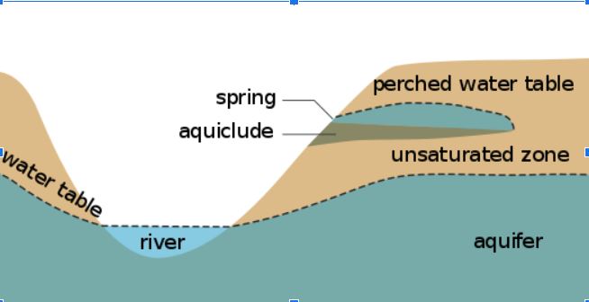
The streams trickling down the slope on the east side of the Kennebec and crossing under the Rotary Trail are likely originating in a perched water table formed by impervious material such as clay of the Presumpscot Formation. You might picture this like a large underground clay bowl containing groundwater. As you can see from the diagram, even when the water table is low, water can still flow from a perched table positioned at less depth.